


Voting District 120001, Washington County, New York
About
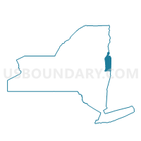
Outline

Summary
| Unique Area Identifier | 638194 |
| Name | Voting District 120001 |
| County | Washington County |
| State | New York |
| Area (square miles) | 37.57 |
| Land Area (square miles) | 37.16 |
| Water Area (square miles) | 0.41 |
| % of Land Area | 98.92 |
| % of Water Area | 1.08 |
| Latitude of the Internal Point | 43.08045660 |
| Longtitude of the Internal Point | -73.38327590 |
Maps


Graphs
Select a template below for downloading or customizing gragh for Voting District 120001, Washington County, New York


Neighbors
Neighoring Voting District (by Name) Neighboring Voting District on the Map
- Voting District 020001, Washington County, NY
- Voting District 020002, Washington County, NY
- Voting District 040002, Washington County, NY
- Voting District 080001, Washington County, NY
- Voting District 080004, Washington County, NY
- Voting District 150001, Washington County, NY
- Voting District 150002, Washington County, NY
- Voting District 150003, Washington County, NY
- Voting District 160001 160003, Washington County, NY
- Arlington Voting District, Bennington County, VT
Top 10 Neighboring County Subdivision (by Population) Neighboring County Subdivision on the Map
- Greenwich town, Washington County, NY (4,942)
- White Creek town, Washington County, NY (3,356)
- Salem town, Washington County, NY (2,715)
- Easton town, Washington County, NY (2,336)
- Arlington town, Bennington County, VT (2,317)
- Cambridge town, Washington County, NY (2,021)
- Jackson town, Washington County, NY (1,800)
Top 10 Neighboring Place (by Population) Neighboring Place on the Map
Top 10 Neighboring Unified School District (by Population) Neighboring Unified School District on the Map
- Greenwich Central School District, NY (6,686)
- Cambridge Central School District, NY (6,547)
- Salem Central School District, NY (4,034)
- Arlington School District, VT (2,317)
Top 10 Neighboring State Legislative District Lower Chamber (by Population) Neighboring State Legislative District Lower Chamber on the Map
Top 10 Neighboring State Legislative District Upper Chamber (by Population) Neighboring State Legislative District Upper Chamber on the Map
Top 10 Neighboring 111th Congressional District (by Population) Neighboring 111th Congressional District on the Map
Top 10 Neighboring Census Tract (by Population) Neighboring Census Tract on the Map
- Census Tract 890, Washington County, NY (4,942)
- Census Tract 920, Washington County, NY (3,356)
- Census Tract 900, Washington County, NY (2,715)
- Census Tract 940, Washington County, NY (2,336)
- Census Tract 9707, Bennington County, VT (2,317)
- Census Tract 930, Washington County, NY (2,021)
- Census Tract 910, Washington County, NY (1,800)